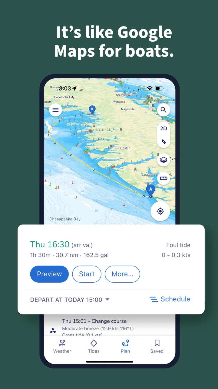
Savvy Navvy Boating Navigation
- 4.2
- Rating
- 500.00K
- Installs
- Free
- Price

 Analysis by App-foxy
When I look at Savvy Navvy Boating Navigation as a daily boating tool, my main impression is that it tries to turn several separate planning jobs into one calmer workflow. Instead of treating navigation, marine weather, tides, fishing information, and depth awareness as unrelated tasks, it brings them together in a single Maps & Navigation app. That makes it especially appealing when I want to prepare a trip before leaving rather than make decisions only after I am already on the water.
Savvy Navvy Boating Navigation is developed by savvy navvy and is available as a free app for everyone. It has built a solid audience, with more than five hundred thousand installs and an average rating of 4.4 from roughly three thousand ratings. Those figures do not make it automatically right for every skipper, but they do suggest that the app has moved beyond being an obscure experiment and is being used by a meaningful boating community.
A practical look at planning, weather, and navigation
I find that the most useful way to approach Savvy Navvy is to treat it as a place to organize a boating decision, not as a button that makes the decision for me. In this section, I’ll look at how its chart, weather, tide, and depth context can shape preparation, and why checking those pieces together is more helpful than simply tracing a route.
You May Also Like

 Blood Strike: 2.5 Anniversary
Blood Strike’s Loadouts Turn Every Drop Into a Tactical Gamble
A close look at Blood Strike’s custom loadouts: how fast access to signature weapons reshapes its battle royale rhythm, rewards preparation, and narrows the gap between fights.

 Pandora - Music & Podcasts
Pandora’s Music Is Easy to Start, but Harder to Recover
Pandora’s strength is its low-effort path from a seed to a station. Its weak spot is how much confidence it asks you to place in connection, setup, and quiet recovery.

 8 Ball Pool
 Is Built on Rivalries, Rematches, and Routine
A close look at the rivalries, rematches, shared routines, and unanswered safety questions that turn a quick pool match into a persistent mobile community.

 Samsung Music
’s Quiet Strength Is Playing What You Already Own
Its reach comes less from spectacle than from dependable access to a personal library. That simplicity is both the app’s strongest retention engine and its ceiling.

 AccuWeather: Weather Radar
AccuWeather Review: A Quick, Clear Forecast for Everyday Decisions
For everyday plans, the best forecast is the one you can understand quickly. AccuWeather makes rain timing, radar, and local conditions easy to act on, with a few trade-offs.

 Hill Climb Racing
Why Hill Climb Racing Still Turns Crashes Into One More Run
A tiny car, a bumpy hill and one more upgrade: Hill Climb Racing keeps resurfacing because its simple chaos makes every near-miss feel personal.
More From Our News Desk



Why the combined approach is useful
The strongest idea here is not simply that the app displays a chart. Plenty of navigation products can show a position on a map. The more useful question is whether I can connect that position with the conditions that may affect the trip. Savvy Navvy brings nautical charts together with marine weather, tides, boat GPS information, and depth mapping, giving me a more complete starting point for a route decision.
That matters because a route that looks straightforward on a chart may feel very different once wind, tide, visibility, and depth become part of the decision. I find the combined view more helpful than jumping between a chart app, a weather service, and a separate tide reference. Every switch between apps creates another chance to lose context or overlook a change. Keeping the information close together makes the planning process easier to follow.
I would not describe this as a replacement for seamanship or local knowledge. It is better understood as a planning assistant that helps organize the information I need. I still need to understand my boat, check the conditions, and use sensible judgment. The app can make that work more convenient, but it cannot remove responsibility from the person in charge.
A realistic day on the water
Imagine planning a short coastal outing with a friend. Before leaving, I can use the chart to think about the route, look at the expected marine conditions, consider how tides may influence the journey, and keep depth information in the same general planning process. If the weather makes the original plan less attractive, I can reconsider the route before loading the boat rather than discovering the problem halfway through the trip.
That workflow is one of the app’s most convincing strengths. It encourages me to plan around the whole trip instead of focusing only on the line from departure to destination. For a casual sailor, that can make preparation feel less scattered. For someone who fishes, the combination of chart context, depth information, and marine conditions may also be more useful than a basic road-style navigation app that knows little about the water.
A small but important habit is to use the app before the trip, not only as a moving map once underway. Looking at the route while I still have time to think makes it easier to notice awkward turns, shallow areas, or weather-related concerns. In my experience, this is where a boating navigation app earns its place: not by encouraging constant screen attention, but by helping me make better decisions before the screen becomes important.
What the nautical focus changes
People coming from ordinary driving navigation should adjust their expectations. Roads usually provide a fairly obvious network of permitted paths. Water is more complicated. A chart requires interpretation, and a depth map is not the same thing as a guarantee that every displayed area is suitable for every vessel. Boat size, draft, local conditions, chart quality, tide state, and current knowledge all matter.
That is why I value the nautical focus here. The app is built around the kinds of information boaters actually consider, rather than adapting a road-navigation design to a marine setting. The presence of marine weather and tides alongside chart information gives the planning screen a more relevant purpose. It also makes the app a better fit for someone who wants one boating-oriented tool instead of several general-purpose services.
At the same time, the richer context can make the app feel more demanding than a simple map. A new boater may see more information than expected and still need to learn what each layer means. I would recommend spending time exploring it on land, when there is no pressure to make a quick decision. Familiarity is particularly important before relying on any navigation display during a busy or unfamiliar outing.
Useful workflows that are easy to overlook
One practical workflow is to compare the planned route with the conditions rather than treating the route as fixed. I can begin with a destination, inspect the surrounding chart, and then reconsider the plan after checking weather and tides. If the timing is inconvenient, changing the departure window may be more sensible than abandoning the trip. The app is most valuable when I use it as a decision-making workspace, not merely as a digital pointer.
Another useful habit is to check depth information in relation to the boat I am actually using. A depth display has meaning only when I connect it with the vessel’s needs and a sensible safety margin. I would not use a tempting-looking passage simply because it appears on the map. Instead, I treat the depth layer as a prompt to investigate and plan conservatively.
Fishing trips provide a different example. A person looking for a location may benefit from seeing fishing-related nautical information in the same environment as depth and marine conditions. The advantage is not that the app makes the fishing decision automatically. The advantage is that it reduces the amount of manual comparison needed when deciding where and when to go.
A third workflow is to use the app for discussion before departure. When traveling with another person, the chart and related information can give both of us a shared reference point. We can talk through the route, possible changes, and the effect of conditions before the engine starts. That is a modest feature of the overall experience, but it can prevent the common problem of making the entire plan in a rushed conversation at the dock.
The main weakness: convenience does not equal certainty
The biggest limitation is also connected to the app’s greatest strength. Bringing many kinds of information together can make planning easier, but it may create a false sense that the complete answer is visible on one screen. It is not. A chart, weather outlook, tide information, and depth map are valuable inputs, yet they still require interpretation and cross-checking.
I would be cautious about treating the app as the only navigation resource on a serious trip. A backup plan remains sensible, especially when traveling somewhere unfamiliar or when conditions are changing. I also would not expect a digital chart to replace local knowledge about hazards, entrances, currents, or unusual conditions. The app can support preparation, but it should not encourage overconfidence.
The interface may also feel more useful to an experienced boater than to someone who wants a completely automatic route. Marine navigation is full of exceptions, and the app’s information is most helpful when I already have a basic understanding of what I am seeing. Beginners can still use it, but I would approach it as a learning tool rather than assuming that every recommendation or displayed route removes the need for judgment.
There is also a financial consideration. The app itself is free to download, while in-app purchases range from about eighty-four dollars to around one hundred sixty-nine dollars per item. That places the paid side of the experience in a different category from a casual free map. Before spending money, I would want to know that I will use the marine planning tools regularly and that the available purchase matches the kind of boating I do.
How it compares with familiar alternatives
Compared with a general map app, Savvy Navvy is far more relevant to boating because its focus is nautical charts, marine weather, tides, boat GPS, and depth information. A standard map may be excellent for reaching a marina by car, but it is not designed around decisions made on the water. For a sailor or angler, that difference is substantial rather than cosmetic.
Compared with using several specialist apps, the advantage is convenience and continuity. I do not have to remember which service contains the tide information or move mentally between unrelated screens as often. The trade-off is that a dedicated specialist may offer a deeper experience for one narrow task. Someone who already has a favorite charting system, a trusted weather source, and a separate fishing workflow may not gain enough from switching.
Compared with paper charts, the app is easier to update mentally during planning and more convenient for checking different layers in one place. Paper still has a role as a dependable backup and as a way to study an area without depending on a screen. I would not frame the choice as digital versus traditional navigation. For responsible boating, the better approach is to understand the digital tool while retaining a backup method appropriate to the trip.
Who should use it, and who should skip it?
I think the app is a strong fit for recreational sailors who want one place to prepare outings, especially those who currently use disconnected tools for charts, weather, and tides. It also makes sense for boaters who fish and want depth-related context included in their planning. The app’s broad marine focus is more useful when I am making route and timing decisions than when I simply need a location marker.
It should also appeal to people who are willing to learn the basics of nautical charts. The best results come from active participation: checking the route, questioning the conditions, and adapting the plan. If that sounds like the kind of preparation you enjoy, the app can make the process more organized and less repetitive.
I would skip it if I only need occasional directions to a marina, if I never plan trips in advance, or if I already have a marine navigation setup that I trust and understand thoroughly. I would also hesitate to recommend paying for the higher-priced in-app options to someone who takes only rare, short outings. The free entry point is useful for evaluation, but the full value depends on regular use.
Device support and everyday accessibility
The Android version requires Android 8.0 or later, so most users with reasonably current phones should be able to consider it. The app is rated for everyone, which fits its role as a practical navigation product rather than entertainment aimed at a restricted age group. Still, an everyone rating should not be confused with beginner-level operation; safe marine use requires attention and sensible training.
The current version is 2.2.22159. I would keep the app updated when possible, particularly for a navigation product where improvements may affect the general experience. Before a trip, I would open it at home, review the planned area, and make sure I understand the route and information layers I intend to use. That simple preparation is more valuable than installing it at the dock and expecting instant confidence.
Another point worth keeping in mind is phone dependence. A phone is convenient, but battery level, screen visibility, handling, and environmental conditions can all affect how practical it is on a boat. I prefer to use the app as part of a wider preparation routine rather than making it the single thing that stands between me and a safe return.
My final recommendation
My verdict is positive, with a clear condition: Savvy Navvy works best for boaters who want to think through a trip using several kinds of marine information at once. Its chart-centered approach, combined with weather, tides, GPS, and depth context, gives it a meaningful advantage over an ordinary map and a more convenient workflow than juggling unrelated services.
Its weakness is not that it lacks ambition, but that a unified display can tempt users to believe that planning is finished once the screen looks complete. I would use it to compare options, identify questions, and prepare a route, while keeping local knowledge, conservative judgment, and a backup approach in the picture.
For a recreational sailor or fishing enthusiast who regularly plans trips, the free download is worth exploring before deciding whether the in-app purchases justify the cost. For occasional users, a simpler tool may be enough. In my experience, the app earns its place when it helps me make a calmer decision before departure; that is a more valuable role than pretending to make every boating decision for me.
My recommendation: try it if you want a marine planning companion, but use its information as guidance rather than permission to ignore the realities of the water.
FAQs for Savvy Navvy Boating Navigation
01What platforms is Savvy Navvy available on?
Savvy Navvy is available for both Android and iOS devices. You can easily download it from the Google Play Store or the Apple App Store, making it accessible to a wide range of users who are looking to enhance their boating navigation experience.
02Does Savvy Navvy require an internet connection?
Yes, Savvy Navvy requires an internet connection to function effectively. It uses real-time data to provide accurate navigation, weather updates, and route planning. While some features may work offline, an active connection is essential for the app's full functionality.
03Can I use Savvy Navvy for all types of boating?
Savvy Navvy is designed for a variety of boating activities, including sailing, yachting, and motorboating. Its comprehensive features cater to different needs, offering tide, weather, and route information that is beneficial for both casual and serious boaters.
04How does Savvy Navvy ensure safety during navigation?
Savvy Navvy prioritizes safety by providing users with up-to-date weather forecasts, tidal information, and navigation alerts. The app's route planning feature helps avoid potential hazards, ensuring a safer journey. Users should always cross-check with local advisories for maximum safety.
05Is there a cost associated with using Savvy Navvy?
Savvy Navvy offers a free version with basic features, but to access its full range of capabilities, a subscription is required. This premium version includes advanced functions like detailed route planning and weather integration, offering more value for serious boaters.
Pros
- Intuitive interface for easy navigation
- Real-time weather updates enhance safety
- Comprehensive route planning tools
- Offline maps available for remote areas
- Integration with multiple marine devices
Cons
- Subscription required for full features
- Initial setup can be time-consuming
- Limited support for smaller waterways
- Occasional map loading delays
- High battery usage during long trips

Savvy Navvy Boating Navigation
Gallery